THE
COASTAL LIBRARY

HOURS:
24 Each Day, 365 Days a Year!
RULES: Learn, Get
Inspired, Have Fun!
OVERDUES: Penalty
For Not Returning
Each Week Is Not Knowing
What's New!
THE
COASTAL LIBRARY
HOURS:
24 Each Day, 365 Days a Year!
RULES: Learn, Get
Inspired, Have Fun!
OVERDUES: Penalty
For Not Returning
Each Week Is Not Knowing
What's New!
The Coastal Library will Provide Quick and Easy Access to Comprehensive, Useful, and Interesting Information related to Coastal Trails . . .
Around The World!It will constantly be Expanded and Developed.
We want it to be So Useful and Entertaining
that You Will Visit It Often!
If you have given us input on topics
that you would like to see included . . . Thank you!
We have been collecting all your suggestions, and will be
incorporting them into our coastal library when time allows.
NOTE: More detailed information
may already be available in book
form about specific coastal trails.
Please look at our Recreation Store
appearing on this website for a brief description of such books.
Please Tell Us What Information, Topics, and other Subject Matter
You'd like in this On-line Library.
- Enter up to 3 Key Words.
- Tell us What they Mean to You.
- Use One Sentence for Each.
2. KEY WORD & SENTENCE
3. KEY WORD & SENTENCE
THANK YOU!
SUBJECT:
COASTAL TRAILSNorth America
The North American continent, especially along it's west coast, has the potential for what could be called a "Continental Coastal Trail." If existing and developing coastal trail systems in the United States, Canada, and Mexico were linked together an incredible long-distance trail spanning from Dutch Harbor, Alaska in the Aleutian Islands to Carbo San Lucas, Mexico at the southern tip of the Baja California Penninsula could be created! This "North American West Coast Trail" would be the first of its kind in the world and provide recreational opportunities primarily for hiking, biking, and kayaking. Read on and imagine the possibilities for personal adventure, discovery, exploration, and odyssey on the edge of infinity along the great Pacific Ocean!United States
National Coast Trail
The National Coast Trail is a concept to literally loop a land and water trail around the entire United States! It would also connect with Alaska and include coastal trails looping around Hawaiian islands. It is composed of trail sections which in their own right represent major long distance trail systems. Specific trail sections would either favor specific user groups or certain forms of recreation would be our recommended, although by no means the only way of actually traveling a specific section. Let's consider each section starting at the West Coast Trail section -- our current priority focus and goal for trail development -- plus Alaska & Hawaii.West Coast Trail
The "West Coast Trail" section (WCT) of the National Coast Trail is primarily a hiking trail along the west coast of the United States directly bordering the Pacific Ocean having a length of about 1800 miles. It begins in the Northwest corner of Washington at the very tip of Cape Flattery and ends just below San Diego, California at the border of Mexico. The West Coast Trail travels down the coasts of Washington, Oregon and California. Since each state already has many coastal trail systems and because the beach is the trail along many sections this all means a great majority of the "WCT" already exists.Washington Coast Trail
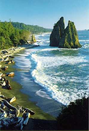
The "Washington Coast Trail" is approximately 200 miles long and passes through Olympic National Park , Native American reservations, wildlife refuges and state beaches. The park itself has built and maintains a designated trail called the "Olympic Coastal Strip" and in itself is a challenge for those who seek wilderness. The trail travels by many rocky seastacks, through temperate rain forests, along stoney and sandy beaches, across rushing rivers, rocky headlands and lighthouses. The hiker needs to ferry across some of the major rivers above Point Grenville and both Gray's Harbor and Willapa Bay. An alternative to ferrying around Willapa Bay is the potential for developing a Willapa Bay water trail and kayak -- a probable collaborative project with the Washington Water Trails Association. Permission is required to hike the Makah and Quinault Reservations. The "WACT" was only recently recognized as an "official trail" on lands under Washington State Parks jurisdiction in July 1998, however, recognition on lands under tribal and federal jurisdiction still needs to occur to have make it official in its entirety. The idea for the Washington Coast Trail is from long-distance coastal hiker and NCTA founder Al LePage. (He had been inspired by his 30-day hike along the entire length of the Oregon Coast Trail in 1988 to wonder if this could also be done along the Washington Coast, and knew it was feasible when he did hike it in 1992.) Approximately 190 miles of this trail already exists; the Makah Tribe completing the only major missing link. Exploring Washington's Wild Olympic Coast by David Hopper and published by The Mountaineers is an excellent resource for both dayhikers or backpackers! Highly recommended maps for this trail include both the "Official Map and Guide" and "The Olympic Coastal Strip" from the National Park Service, Olympic N.P., the "Custom Correct Maps" of the North and South Olympic Coasts from Little River Enterprises in Port Angeles, WA and USGS topographic maps of the coast.
The Olympic Discovery Trail being developed from Port Townsend to Port Angeles, WA could perhaps be extended all the way to the Pacific Ocean, and thus someday connect with the Washington Coast Trail.Oregon Coast Trail
The Oregon Coast Trail is approximately 400 miles long and passes through Oregon StateParks, the Oregon Dunes National Recreation Area, national forests and along Highway 101. The trail begins at the south jetty of the Columbia River and travels along sandy beaches, through temperate rainforests, up mountains, over rocky headlands, across rivers and streams and by lighthouses. The hiker needs to ferry across some of the major rivers and bays of Oregon. In order to make a connection with the trail in Washington, the hiker needs to take a charter boat from the dock in Ilwaco, WA to the dock in Warrenton, OR. The trail link from Oregon to California is easy -- just keep walking south over the invisible state line somewhere in the beach sand. The "OCT" is an official trail under the management Oregon State Parks and was the idea of a University of Oregon geography professor, Samuel N. Dicken back in the 1950's. (He had been inspired by the beauty of the Oregon Coast, his belief in making it accessible to the public, and his knowledge of the continuous long-distance Appalachian Trail.) Approximately 350 miles of this trail are complete; declared "hikable" in 1988 by Oregon State Parks. Exploring the Wild Oregon Coast by Bonnie Henderson published by The Mountaineers and 100 Hikes/Travel Guide, Oregon Coast & Coast Range by William L. Sullivan published by Navillus Press are excellent resources for both dayhikers or backpackers! Henderson includes a special section on the Oregon Coast Trail and Sullivan includes potential sections of the Washington Coast Trail in the Long Beach area and of the California Coast Trail in the Redwoods and Crescent City areas. Highly reccomended maps for this trail include "Oregon Coast Trail Guide" produced by and sent free of charge from Oregon Parks and Recreation Department and USGS topographic maps.
FOOTNOTE: Members of the Lewis & Clark Expedition traveled along a northern section of the existing Oregon Coast Trail over Tillamook Head. The expedition built Fort Clatsop during their stay at the Pacific Ocean, and a trail from the fort to the ocean may someday be constructed connecting with the Oregon Coast Trail itself.California Coastal Trail
The California Coastal Trail is approximately 1200 miles long and passes through RedwoodNational Park, Point Reyes National Seashore, around Monterrey Bay, along Big Sur, the Santa Monica Mountains National Recreation Area and Highway 101. The trail travels all the way to the Mexican border and goes through cool and lush redwood and warm and arid chapperal forests, it climbs up towering mountains and over dunes, it passes far-off islands and huge bays, there are rocky coasts, sandy beaches and pastures and, of course, the "civilization and people" of California! Mendocino, Monterey, Malibu, San Francisco and the Golden Gate Bridge, Santa Barbara and the old Spanish missions, Los Angeles and Hollywood and San Diego and its zoo! It's a big trail with lots to see on the way. The hiker needs to ferry across some major rivers, and might prefer to charter a boat on inaccessible sections of the northern coast instead of walking along the highway. The "CCT" is an "official trail" recognized and essentially being developed by various state government agencies in California. The idea for a "CCT" had been floating around for quite some time when John McKinney, Los Angeles Times hiking columnist and hiking author, founded the California Coastal Trails Foundation and wrote the book California Coastal Trails. (He had been inspired by a British naturalist and author who had written the book California Coast Trails after he had ridden a horse from Mexico to Oregon early in the 1900's!) Hiking The California Coastal Trail, Volume One: Oregon to Monterey (Volume Two in preparation) by Bob Lorentzen and Richard Nichols published by Bored Feet Publications and Walking the California Coast, One Hundred Adventures Along The West Coast by John McKinney published by HarperCollins West are excellent resources. Approximately 700 miles of this trail is complete; it continues to be a work-in-progress. Highly recommended maps for this trail can be found in the already mentioned book Hiking The California Coastal Trail and USGS topographic maps are also useful.
FOOTNOTE: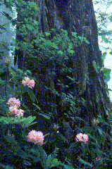
An especially beautiful section of the California Coastal Trail travels through Redwood National and State Parks in northern California and provides backpackers with an opportunity to create a week long trip through redwood forests, grassy praries, sandy beaches, and along a rocky coastline.Alaska Coast Trail
The "Alaska Coast Trail" is a concept to develop a "coastal trail" utilizing the Alaska Marine Highway Ferry System to access existing local coastal and spur trails along its route. The first part of the trail would either begin at Bellingham, Washington where the Alaskan Marine Highway service begins or at Prince Rupert, British Columbia, Canada where the BC Ferry System connects with the Alaska Marine Highway. (The Prince Rupert connection would be for those travelers who utilized The Sunset Coast Trail along Vancouver Island to reach Port Hardy, British Columbia -- where you can take the BC Ferry System to Prince Rupert. The "Inside Passage" section of the Alaska Marine Highway would eventually bring you to Skagway and Haines in southeast Alaska. In Skagway you could take the famous Chilkoot Trail, an example of what we would consider a "spur trail" along the National Coast Trail. Historic buildings and musuem exhibits in Skagway also include portions of the White Pass Trail, all prominent in the 1898 gold rush, and are included in the Klondike Gold Rush National Historic Park with a National Park Service visitor center located downtown. Alaska Marine Highway Ferry Service is quite frequent in southeast Alaska but makes only makes trips once a month from Southeast to Southwest Alaska with connections from Juneau, AK, Prince Rupert, BC, and Bellingham, WA. However, for those who want to continue under their own power and cycle into the interior to eventually reconnect with the ferry system could possibly choose this challenging alternative! A cyclist could continue from either Haines or Skagway until reaching Valdez, Alaska -- but remember timing is everything because the ferry only stops here once a month! You'd continue to explore the Alaska coast as the ferry made its way along the chain of Aleutian Islands until reaching its last stop out by Unalaska and Dutch Harbor! Part of the challenge of doing the Alaska Coast Trail will be logistical planning around ferry schedules! The Alaska Coast Trail as a trail concept still needs to be extensively developed.Books to check out at your local bookstore or library include:
[ADDITIONAL DATA ENTRY TO BE DONE IN THE FUTURE.]
Alaska Bicycle Touring Guide, by Pete Praetorius and Alys Culhane, The Denali Press, 1992Hawai'i Coast Trail
The "Hawaii Coast Trail" is a concept to link existing hiking trails, biking routes, andcurrently used areas for kayaking to create continuous coastal trails around many of the Hawaiian islands. A trail concept being seriously considered is the Ala Ka Hakai Trail -- an idea to develop a continuous "Trail by the Sea" of approximately 175 miles along a portion of the prehistoric ala loa (long trail) roughly paralell to the seacoast in Hawaii. It would extend from 'Upolu Point on the north tip of Hawai'i Island down the west coast and around Ka Lae (South Point, literally, "The Point") to the east boundary of Hawai'i Volcanoes National Park. In prehistoric times, the ala loa circled the entire island. This information is based on Ala Kahakai, National Trail Study and Final Environmental Impact Statement done by the National Park Service, January 1998.
FOOTNOTE: This is a TRAIL CONCEPT which will be considered for National Historic Trail Status by the US Congress early in 1999 and neither exists IN ITS ENTIRETY nor is accessible IN ITS ENTIRETY at this time.Books to check out at your local bookstore or library include:
[ADDITIONAL DATA ENTRY TO BE DONE IN THE NEAR FUTURE.]
Paddling Hawai'i, by Audrey Sutherland, The Mountaineers, 1988
An Insider's Guide To Exploring The Secluded Coves, Jungle Streams, and Wild Coasts of the Hawaiian IslandsOTHER TRAIL SECTIONS ALONG THE NATIONAL COAST TRAIL
[ADDITIONAL DATA ENTRY TO BE DONE BY OCTOBER 1999.]Southwest Border Trail
Gulf Coast Trail
East Coast Trail
This section of the National Coast Trail is envisioned as being a "water trail" using sea kayaking as the primary form of recreation. It would stretch approximately 2,000 miles from the Florida Keys to the coast of Maine itself! One would travel the edge of the Atlantic coast utilizine existing facilities and services for public access and camping as well as sections of the intracoastal waterway when feasible. It would offer everyone the opportunity to discover scenic beauty, a rich history, and diverse cultures along the east coast of America.
- CAPE COD
Cape Cod National Seashoreprovides the public access to hike along "the bare and bended arm" of Cape Cod, and allows one to travel this part of the East Coast Trail section on land instead of the suggested kayaking by water trail along the coast from Florida to Maine.
Cape Cod Pathways abound in other areas of Cape Cod and useful information is available through the link just listed as well as one devoted to walking Cape Cod.
New England TrailNorth Country Trail
Lewis and Clark Trail
Pacific Northwest Trail
Canada
The upper portion of the National Coast Trail will paralell the Canadian border and will link up with Alaska through British Colunbia. In fact, the National Coast Trail may actually cross over the border to link up with east-west trail sections in Canada itself.Trans-Canada Trail
The The Trans-Canada Trail Foundation is presently working to develop The Trans-Canada Trail which is expected to stretch from "coast to coast to coast" -- from the Atlantic to the Pacific to the Artic Oceans! Linking into this trail system along the border may be an option for us to consider. We have actually developed a unique trail concept which we have presented to them as an extension of their current idea -- which they end in Victoria, British Columbia on Vancouver Island in the Pacific. Our concept is to extend their idea by 450 miles and develop what we call The Sunset Coast Trail!Sunset Coast Trail
The Sunst Coast Trail would be a 450-mile combination biking, hiking, and kayaking trail running along the west coast of Vancouver Island starting in Victoria and ending in Port Hardy. It would essentially link up existing trails and recreational areas currently being used not only to create a world class coastal trail but also provide a link from Washington to Alaska for the National Coast Trail!West Coast Trail
One trail system it would incorporate would be Canada's famous West Coast Trail -- a rugged 45 mile trek through coastal wilderness in Pacific Rim National Park. Be sure you're in great shape ad be sure you're prepared if you decide to do this trail because its really tough! We've developed a Fact Sheet and Resource Guide for the Sunset Coast Trail.Books to check out at your local bookstore or library include:
[DATA ENTRY TO BE DONE IN THE FUTURE.]
Fact Sheet and Resource Guide for the Sunset Coast Trail
(TO BE ADDED IN FUTURE)Mexico
Baja Coast Trail
The Baja Coast Trail (BCT) could become a "spur trail" off the National Coast Trail as it "turns the corner" near San Diego at the Mexican border where The West Coast Trail section ends and the Southwest Border Trail begins. It's a beautiful but rugged section of coast "where the desert meets the sea." Our concept would begin this trail at Tiajuana, Mexico by crossing the border at San Ysidro, California and with hiking, kayaking, and biking being the preferred user groups. The trail would travel directly along the Pacific Ocean and end in Carbo San Lucas on the southern tip of the Baja Pennisula. We know of one person who actually walked around the entire Baja Pennisula in 500 days! His name is Graham Mackintosh and luckily for you he wrote a book about it -- Into A Desert Place, A 3000 Mile Walk Around The Coast Of Baja California.Other books to check out at your local bookstore or library include:
Bicycling Baja, Cyclist's Guide to Major Scenic and Historic Routes Through Fabulous Baja California
by Bonnie Wong
Sunbelt Publications, 1988.
No frills guide to Hiking in Mexico, Jim Conrad with Steven Vale and others
Bradt Publications, 1992.
[ADDITIONAL DATA ENTRY TO BE DONE IN THE FUTURE.]SUBJECT:
INTERNATIONAL COASTAL TRAILS"INTERNATIONAL COAST TRAIL"
The International Coast Trail (ICT) is a concept for a land and water based "continuous global loop" trailsystem along the coastlines of all the continents of the world! In essence, this would create the longest trail -- coastal or otherwise -- on earth! It would be an impressive task to develop such a trail and would require the coordination and cooperation of millions of volunteers and thousands of government agencies and nonprofit organizations! The concept was suggested in our bylaws which were written by it's founder and current executive director, Al LePage. One of our purposes is to participate in International Coastal Trail development. This website gives us the ability to do so in a significant way for the first time. Therefore, we will provide information and links about coastal trails all over the world and provide other assistance as other priorities and our resources allow. North America has already been mentioned, therefore, the remaining continents remain as follows:
Africa
South Africa
[INFORMATION TO BE RESEARCHED AND DEVELOPED.]Antarctica
Antarctic Coast Trail
An International Coast Trail just wouldn't be complete without this remote continent being included. What could be called the "Antarctic Coast Trail" would be an incredible experience to one of the world's most remote places! Peguins, Icebergs, Explorer's Historic Sites, Scientific Research Stations, Blinding Whiteness, and Deep Blue Sky! Visit our Travel Center -- and look under TOURS, Antarctica to learn more about how you could actually visit the coast of Anarctica!Asia
[INFORMATION TO BE RESEARCHED AND DEVELOPED.]Austraila
Victoria -- The "Great South West Walk"Northeast Coast -- The first Section of theBicentennial National Trail from Cooktown to Mossman travels in from and out to the coast through tropical rainforests. Crocodiles are a danger!
Europe
Great Britain
England
Scotland
Wales -- The Pembrokeshire Coast Path is a world-class coastal trail with opportunities
to explore scenic beauty, history, and the culture of Wales along 186 miles of its coast!
Simply click Pembrokeshire Coast National Park and look under . . .
"Enjoying the National Park . . . Things to do . . . Pembrokeshire Coast Path"
South America
[Information to be researched and developed.]SUBJECT:
PUBLIC ACCESSGreat Britain
Great Britain is probably one of the best places in the world for public access.
Both the non-profit Rambler's Association and the government's Countryside Agency
are concerned about public rights of way.SUBJECT:
COASTAL PRESERVATIONEngland
32% of scenic English coastline is conserved as "Heritage Coasts."
SUBJECT:
OPEN SPACESUBJECT:
WILDLIFE HABITATSUBJECT:
CULTURAL RESOURCESSUBJECT:
HISTORIC RESOURCESSUBJECT:
CONSENSUSFURTHER SUBJECT AREAS
TO BE DEVELOPED AND
EXPANDED
THIS PAGE WILL CONSTANTLY BE UNDER CONDSTRUCTION